
Apache Lake
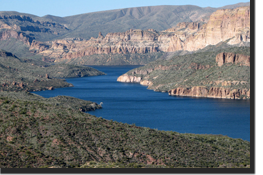 Apache Lake is Formed by Horse Mesa Dam, Apache Lake is long and narrow and is the second largest Salt River Project lake. It is located off the Apache Trail (Highway 88) about 65 miles from Phoenix, and is a favorite with many sportsmen, particularly those from southern Arizona.
The Apache Lake Marina and Resort is one mile from the main highway and features a motel, gas station, coffee shop, picnic supplies and a trailer park for 12 units. A boat ramp and dock are at the resort, and a county sheriff’s aid station is nearby.
The Three Bar Wildlife Area is just across the lake from the resort and provides a scenic spot for photographers. Seven miles northeast of the resort is the Burnt Corral Recreation Site with 17 spaces for trailers which are less than 17 feet long. The area is open all year and has boat launching facilities.
Game fish in Apache Lake include walleye, largemouth and smallmouth bass, red ear sunfish, bluegill, channel catfish and crappie.
State Park Contact Information:
Tonto National Forest -Tonto Basin Ranger Station
28079 N. Az Highway 188
Roosevelt, AZ 85545
Phone: 928-467-3200
Information provided by: Go-Arizona.com
Bartlett Lake
 Bartlett Lake has a boatable surface area of 2,815 acres – more than Canyon Lake and Saguaro Lake, combined. Fed by the pristine waters of the Verde River, Indians of this valley spoke descriptively in their legends of the river’s “sweet waters”.
Outdoor enthusiasts frequent Bartlett Lake for a variety of recreational opportunities, including shoreline camping in Arizona’s natural desert terrain. While in this part of the Tonto National Forest, visitors may see mule deer, bald eagles, javelina, coyotes, and many indigenous desert plants, including the majestic saguaro, mesquite trees and blooming ocotillo.
Bartlett Lake is located only 48 miles from downtown Phoenix and 20 miles east of Carefree. The newly engineered, fully paved, scenic Bartlett Lake Road combined with the expanding Phoenix freeway system offers easy access from the entire Valley of the Sun. Tonto National Forest campground improvements, handicap accessibility, and safety features provide for safe, enjoyable recreation including hiking, boating, water skiing and fishing. Boat rentals are available on the lake for those who don’t have their own boats.
Cave Creek Ranger Station
40202 North Cave Creek Road
Scottsdale, AZ 85262
Phone: 480-595-3300
Fax: 480-595-3342
Information provided by: Go-Arizona.com
Roosevelt Lake
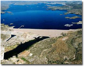
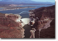 Theodore Roosevelt Dam, the first major structure constructed by the Bureau of Reclamation on the Salt River Project (SRP), spans the Salt River to form a huge reservoir. The dam is 280 feet high and 723 feet long. Once the largest man-made lake in the world, Roosevelt Lake is still the biggest of the six SRP lakes and offers the most recreation opportunities. When full, the lake covers more than 17,000 acres near the confluence of Tonto Creek and the Salt River.
Game fish in Roosevelt include largemouth and smallmouth bass, bluegill, channel catfish and crappie. The Lake contains a wildlife area and as a wildlife refuge, is posted to permit hunting at certain times of the year.
Tonto Basin Ranger Station
HC02 Box 4800
Roosevelt, AZ 85545
Phone: 928-467-3200
Fax: 928-467-3239
Information provided by: Go-Arizona.com
Lake Havasu
Lake Havasu City h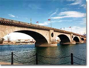 as a well-deserved reputation as a raucous Spring Break destination. In Spring college students fom around the West descend on Lake Havasu to party on the lake by day and in the clubs by night. Lake Havasu City is a thriving tourist town with plenty of lodging, tours, rentals and shopping to support even the largest of Spring Break crowds.
Lake Havasu itself is 45 miles long and is actually a Colorado River reservoir that was created when the Parker Dam was completed in 1938. It is a desert lake surrounded by cliff walls and offers plenty of room for boating.
Lake Havasu City is also home to the famed London Bridge and under the bridge there is an English Village of shops and restaurants.
Lake Havasu City is located on the Colorado River on the Western Border of Arizona. It is about 60 miles south of Bullhead City. Phoenix is 200 miles southeast.
Information provided by: Go-Arizona.com
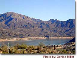
Lake Pleasant
 Lake Pleasant is the largest lake in the Greater Phoenix area located about 30 miles north of Phoenix within the city limits of Peoria, a Phoenix suburb. The lake features over 50 miles of shoreline with 10,000 acres of crystal clear water fed primarily from the Agua Fria River.
The lake was originally created in the 1920s with the building of the “Carl” Pleasant Dam which was later renamed as Waddel Dam. A new larger dam was constructed in 1992 which tripled the size of the lake. The original dam now lies under 100 feet of water.
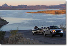
Lake Pleasant is a water-lover’s and boating enthusiast’s paradise that includes camping, boating, house boating, sailing, water skiing, jet skiing and fishing. There are two paved boat launching ramps including a 10 lane and a 4 lane ramp. The adjacent parking lot will accommodate over 700 vehicles. The Pleasant Harbor Marina is full-service with wet slips, a convenience store, dry storage, and fuel service. They also have a boat repair center, a deli and a dockside bar. Boats are available for rent.
Fishing At Lake Pleasant
Anglers have experienced trophy-size catches at the lake with a wide variety of sport fish including largemouth bass, white crappie, white bass, channel catfish, and talapia. The salt water species of striper bass were introduced to the lake as water containing striper fry and eggs is pumped into the lake from the Colorado River via the Central Arizona Project canal.
Several creeks and washes feed into the lake and the feeding points are considered as hot fishing spots. They include Humbug Creek, Castle Creek and Cole’s Wash. Although fishing can be good from the shore, it takes a boat to get to the heavy action locations. Pleasant features the best bass fishing in the area.
Lake Pleasant Regional Park
41835 N. Castle Hot Springs Rd.
Morristown, AZ 85342
Contact Station 928-501-1710
Operations Center 602-372-7460
Information provided by: ArizonaLeisure.com
Alamo Lake
 Alamo Lake State Park is one of Arizona’s best kept secrets. The stark desert beauty is reflected off the water. Cacti dot the mountainous landscape that surround the lake. Nestled in the Bill Williams River Valley away from the hustle and bustle of everyday life, Alamo Lake State Park offers outdoor fun, premier bass fishing, rest and relaxation. For nature lovers, spring rains bring an abundance of wild flowers and the lake environment attracts a variety of wildlife year round, including bald and golden eagles, waterfowl, foxes, coyotes, mule deer and wild burros. Stargazers are sure to enjoy the unbelievable view of the night sky with the nearest city lights some forty miles away!
Alamo Lake, located on the Bill Williams River where the Big Sandy River and Santa Maria River come together, was created with the completion of Alamo Dam in 1968. The Army Corps of Engineers designed the earthen dam primarily for flood control. During flood events, the lake basin is capable of “capturing” large amounts of water in a relatively short time. The lake has been recorded rising 11 vertical feet in one night! Unusually high flows during the late 1970s and through the 1980s have increased the average size of the lake, helping to create one of Arizona’s best fishing holes.
State Park Contact Information:
Alamo Lake State Park
P.O. Box 38
Wenden, Arizona 85357
Phone: 928-669-2088
Information provided by: AZ State Parks